
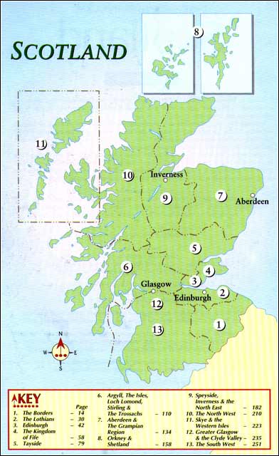
|
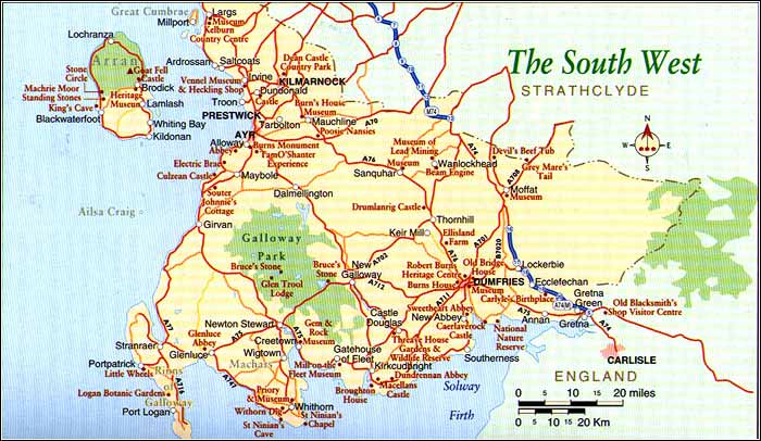
Dumfries and Galloway
By the fifteenth century it was gradually integrated into a unified Scotland. To look at, it is a soft, green, placid area but this belies the violent events of Dumfries and Galloway's history. Galloway, as it was known then, was a stronghold for the Covenanters who resisted the influence of Episcopalian dogma and paid the price. The Gaelic translation of Galloway means 'Land of the Stranger,' but it certainly is a friendly place that makes visitors feel most welcome. Fishing, farming and tourism make up the bulk of the local economy. It is set apart from the main tourist routes. There are no motorways crossing it apart from the M74 going north and south on its eastern perimeter. Outlined between the Firth of Clyde and the Solway Firth, the main access routes are the A77 from Glasgow, the A75 roughly following the Solway Firth from Gretna to Stranraer, and the A76 dropping down from Kilmarnock to Dumfries. Stranraer is a nodal point in the area, mainly because of its connections across the sea to Ireland. Stranraer's economy, once based on its role as a market centre, has increasingly turned to the ferry traffic that constantly pours in and out of town. B&B's and small hotels line the foreshore at Harbour Street and Market Street and the town centre has a few eating places geared to passing trade. There is little else to recommend, but it is a good accommodation base if you wish to explore this area. Rhinns The long, rocky-shored annex of land adhering to Galloway to the west is known as the Rhinns. There are plenty of short tours available around this near-island, but most people head first-of-all along the A77 from Stranraer to the harbour town of Portpatrick. This is a quintessential holiday retreat with charming streets and cottages and a tranquil harbour backed by small cliffs.
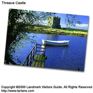
Portpatrick's centre is a place to leave the car and wander amongst craft shops and cafes to enjoy the refreshing air that blows off the Irish Sea. There is a fascinating museum called Little Wheels where model enthusiasts of all kinds can gather and relive childhood memories. It is from Portpatrick that the Southern Upland Way commences its trail across Scotland's borderlands. Above town are two good golf courses, the Dunskey course being the more challenging. A round-trip tour of the Rhinns to the Mull of Galloway covers some 50 miles (80 km) from Stranraer. The main attraction of this largely dairy herd inhabited and gorse bush encrusted area is its coast with secluded stretches of sand and pleasant little harbour villages such as Port Logan. Here you find Logan Botanic Gardens, an annex of Edinburgh's Royal Botanic Gardens with sub-tropical plants such as tree ferns and cabbage palms flourishing outdoors in the mild Gulf Stream climate. The A75 to Dumfries Returning to the main route from Stranraer, 3 miles (5km) east of there on the A75 is Castle Kennedy, best known for its 75 acres of carefully landscaped gardens that are set out on a thin strip of land between the Black Loch and the White Loch. The best time to visit here is in late spring when thirty-seven varieties of rhododendrons and azaleas are in their prime. Glenluce Abbey just off the A75 travelling east is the remains of a twelfth century abbey and well worth stopping for, with its magnificent fifteenth century Chapter House. A thirteenth century wizard, Michael Scott, supposedly saved the Glenluce community when he enticed 'the plague' into the church vault and left it there until it starved to death. The recently opened Pilgrim's Way traces the medieval route used by religious travellers which commences at Glenluce Abbey and wound through the Machars to the important religious site at Whithorn. The A75 cuts directly across this area called the Machars to Newton Stewart. The Machars is rather flat with the two main towns of Whithorn and Wigtown being its best enticements. Whithorn is the true birthplace of Christianity in Scotland. St Ninian, a fourth century bishop, perhaps a local man who had gone to Rome to become consecrated, landed here in AD397. He built a church called Candida Casa or the White House and set about converting the Southern Picts and Britons. A priory was built on the site of the first church and the site became a special place for pilgrims for many centuries up until the time of the Reformation. The history of the original church, the priory and Christianity in Britain is well documented in a small museum nearby. The Whithorn Dig is currently being carried on around the site of the early church to further reveal the area's important ecclesiastical connections. Guided tours around this are essential to grasp the full archaeological significance. A short excursion to the Isle of Whithorn, 3 miles (5km) further south-east, is worthwhile and well sign-posted from Whithorn. There is a small chapel dedicated to St Ninian and it was here that pilgrims would land, having crossed the Solway Firth from England or from further abroad. St Ninian's Cave, some 3 miles (5km) from Whithorn on the west side of the Machars and a walk to the shore from the car park at Kidsdale Farm, is an intriguing place where St Ninian is supposed to have sought repose. There are several crosses carved into the rock inside the cave. Wigtown, 11 miles (18km) north of Whithorn on the A746, is an unsophisticated little holiday town. From the hill on which the town is built you can see Bladnoch Bay and the stone pillar that marks the spot where two martyrs, Margaret McLachland and Margaret Wilson, were tied to stakes and drowned as the tide rose around them. Their crime was attending the illegal Covenanter's prayer meetings and opposing Episcopalians. Returning to the A75 the typical Galloway town of Newton Stewart sits on the banks of the River Creel The local museum is located in St John's Church on York Road and contains information on the district's history. Game fishing is popular in this area and permits can be obtained from the Creebridge House Hotel near the old bridge. The best access point into Galloway Forest Park is via the A714 north of Newton Stewart to Glen Trool Village then following the minor road to Glen Trool Lodge. Galloway Forest Park comprises of some 190,000 acres (76,000 hectares) of hills, lochs, moorland and forest that is a haven for wildlife. The Merrick at 2,766ft (844m) is the highest peak in the south of Scotland. It is worth the steady, fairly demanding hike to enjoy the views over Glen Trool. Start at the car park at Bruce's Stone. The route to New Galloway called the Queen's Way passes through some of the Galloway Forest Park where the Forestry Commission have mapped out various walking trails near to the road. The A75 branches south and east towards Gatehouse of Fleet and Kirkcudbright with Castle Douglas further east. At Creetown, some 6 miles (l0km) south of Newton Stewart, is the Gem Rock Museum, a cavern of over 10,000 specimens of gem stones, crystals and minerals from around the world. The village of Gatehouse of Fleet, a further 12 miles (19km) along the coast of Wigtown Bay, is a good example of late eighteenth century town planning spurred on by the rise of a cotton industry that was developed by James Murray. This industrial boom lasted for nearly 100 years before other towns took over and Gatehouse slipped back into obscurity. The Mill-on-the-Fleet Museum gives credit to the town's hey-day. Kirkcudbright, pronounced 'Kircoobrie,' is a delightful centre of fishing and agriculture as well as tourism. MacLellan's Castle is in the centre of town, a fine model of Scottish fortified architecture. The detached little town has been an enclave for artists and still is a draw for landscape painters. The Tolbooth Art Centre features an audio-visual show, permanent art exhibition, artists studios, a café and shop. The Stewartry Museum next door is a traditional museum reflecting the human and natural history of the eastern part of Galloway. On the Lochfergus Plantation above the town is the Kirkcudbright Wildlife Park with over 100 animals including many native Scottish species. A few miles south there is a pleasant drive to Brighouse Bay that has one of the best caravan/holiday parks in the UK. It also has its own excellent 9-hole golf course soon to be extended to 18. Dundrennan Abbey graces the southern loop of the A711 to Dalbeattie and Castle Douglas, a ruin of a sizeable Cistercian Abbey founded in 1142. In 1568, Mary Queen of Scots spent her last night in Scotland here before she sailed for London and execution. Threave Gardens and Wild Fowl Refuge, just west of Castle Douglas, set in 60 acres (24 hectares) is the training grounds of the National Trust for Scotland's horticulturists. There is a walled garden and green-houses surrounded by various peat, rock and woodland garden projects. The Wildlife Refuge on the marshy banks of the River Dee is equipped with observation points from which to observe several species of duck and geese.
Castle Douglas is another planned village of the eighteenth century, laid out by William Douglas, a local lad who made good in West Indies trading. His ambitions included transforming Castle Douglas into a prosperous centre for commerce and industry along with a canal system serving this part of Galloway, neither of which came to full fruition. West of Dumfries The A710 and A711 meeting at Dalbeattie form a final lobe on the Solway Firth's north coast that makes a good day's tour from the nearby centre of Dumfries. Passing through the Dalbeattie Forest to the hamlets of Kippford and Colvend, the route offers some breathtaking views over the village of Sandyhills to the wide Mersehead Sands. The village of Southerness, set on a point, is popular as a holiday and caravanning centre and has probably the best golf course in the south-west. There are magnificent beach-side walks here stretching for miles in either direction. Eight miles (13km) from Dumfries in the tiny village of New Abbey is 'Dulce Cor' or Sweetheart Abbey, one of the most elegant medieval buildings of this area and the last Cistercian foundation in Scotland. New Abbey village itself is very gracious with delightful cottages lining the main road and an endearing village centre that gets congested with any more than four parked cars. There is ample parking next to the abbey from which to explore the village and the abbey ruins. Also nearby is Shambellie House with its museum of costume, an elegant country house that displays period costume, accessories, furniture and paintings. Dumfries The central community of Dumfries and Galloway is Dumfries, a red-sandstoned town of sturdy character beside the River Nith. Known as the 'Queen of the South' it became established as a seaport and trading centre from the Middle Ages. Being close to the English Border, it was regularly invaded and flattened, especially during the fifteenth and sixteenth centuries. Despite this it has remained important as the focus of this area's agricultural prosperity. Burns House, where he spent his last three years before his death in 1796, is found in what is now called Burns Street, near the southern end of the High Street. Stop at the Globe Inn on the way, one of Burns favourite taverns and still retaining great character. Burns' House is now a small museum full of correspondence and manuscripts relating to the poet. An upstairs bedroom-study where he worked contains his writing desk and, on a window-pane, the etching of his signature perhaps carved there in a moment of absorbed contemplation. The box-bed is original and is where he died. The Burns Mausoleum in the grounds of nearby St Michael's Church is where the bard is buried along with Jean Armor, his wife and several of their children. Near the centre of town where the High Street meets Buccleuch Street is a statue of Burns. Friars Vennel leading from the High Street to the ancient Devorguilla Bridge is one of Scotland's oldest streets. Across the River Nith on the Devorguilla Bridge is the Old Bridge House Museum containing furniture and everyday articles from households of the area. The Robert Burns Heritage Centre, sited in an old mill slightly further down river explores the years that Burns spent in this area. Dumfries Museum sits nearby on the side of a hill. Overlooking the town and river, Dumfries Museum contains local collections on geology and social history. There is a working Camera Obscura on the upper floor of this eighteenth century windmill, one of the three found in Scotland. North of Dumfries
Further north on the A76 is the area known as Nithsdale, excellent for fishing and further into the Lowther Hills, for its stark scenery. The village of Thornhill straddles the A76 and there is a tenth century Anglican cross seen at the Nith Bridge to the west of the town. To the east is Thornhill Golf Club - highly recommended. The smithy at Keir Mill was where the world's first pedal cycle was constructed. Further inland along the B729, Maxweltown House, a museum and grounds open to the public, was the birthplace of Annie Laurie, the subject of the seventeenth century poem and song. Drumlanrig Castle is found just off the A76, a short drive north of Thornhill. It is the home of the Duke of Buccleuch, an immense mansion rather than a fortified stronghold built by the first Duke of Queensberry in 1689. Apparently the Duke only stayed one night in his new home, deciding after that he did not like it. The interior is a repository of artistic treasures including Rembrandt's Old Woman Reading and Leonardo Di Vinci's Madonna with the Yarnwinder. Sanquar is a staging post on the Southern Upland Way most noted for its Tolbooth, now a visitor centre and museum for the local region. There is also the oldest post office in Britain, still working today and in commission in 1763. Following the Mennock Pass on the B797, you find the villages of Wanlockhead and Leadhills, once the centre of a metal mining industry that survived from the Middle Ages until early this century. Wanlockhead, at 1,380ft (421m), is Scotland's highest village, its cottages reflecting the time when they were 'company' designed, built and owned. The Museum of Lead Mining is dedicated to the lead mining industry and shows artefacts of the trade as well as the lifestyle of the miners. There is a water-powered wooden beam engine nearby and also a narrow mine-shaft, the Lochnell Mine, that can be descended on a guided tour if you are not claustrophobic or averse to wearing a hard-hat. Rare minerals and mining artefacts are on display n the Visitor Centre. Gold and silver mining was common here also, and gold panning stills goes on today in some of the peaty burns that roll off the hills. East of Dumfries The area east of Dumfries is arable land with Annan being the chief centre of population. The main attraction on this part of the Solway's coast is Caerlaverock Castle, a solid chunk of thirteenth century architecture. The most scenic route to get there is following the B725 along the mouth of the Nith. The archetypal, turreted castle was improved by the first Earl of Nithsdale in the seventeenth century who added a much refined interior to its formidable facade before it was turned to ruin again by the Covenanters soon after the Earl's work was complete. A mile or so further on is the entrance to Caerlaverock National Nature Reserve, 1,400 acres (560 hectares) of salt-marsh and mud-flats where legions of twitchers' spend hours in hushed concentration until a particularly scarce specimen comes in view of their telescopes. Annan is by-passed by the A75 making it a quiet back-water with its town hall and a carved tablet built into its walls being the main piece of historic fascination. The Brus Stone was held to be part of a castle built by the Brus lords and is inscribed 'Robert de Brus', possibly relating King Robert the Bruce. The celebrated community of Gretna Green is 10 miles (16km) on at the Scottish/English border. Until 1856, eloping English couples could cross the border and be united over an anvil by the local blacksmith. This 'trade' continued until 1969 as Scotland did not require parental consent for marriage after the age of 16. The Old Blacksmith Shop displays the anvil, photographs and documents from this period. For one of the best meals the north side of the border, stop at the Riverside Inn in Canonbie near Langholm which also has some comfortable accommodation. The village of Ecclefechan was the birthplace of the essayist and historian, Thomas Carlyle. The Arched House, as his family home was called, is now a museum dedicated to this brilliant man of letters. His gravestone stands in a churchyard behind the cottage. Lochmaben on the A709 claims to be the birthplace of Robert the Bruce whose statue glowers down upon the main road. The route north The upgraded M74 motorway carries traffic north to Lockerbie, Moffat and Langholm. Before the disaster that came upon it, Lockerbie was a simple little market town. Today, the memories of the Pan-Am flight that fell from the sky following the explosion of a terrorist bomb are irrevocably attached to the place. There is a Garden of Remembrance attached to the town's graveyard at the north end. Surrounded by the stern Southern Uplands, Moffat is set only a mile or so from the main motorway. Its broad High Street is a touch 'continental' with a wide boulevard, divided by trees. In the late seventeenth and eighteenth centuries Moffat became a popular spa resort, owing to its sulphurous waters that still pour from two mineral springs. Moffat is a good place to stop for a day or two with plenty of choice in B&B accommodation. There is a hilly 18 hole golf course overlooking town and Moffat Museum describes the town's important links with the sheep trade. To the north of Moffat following the A701 there is a deep, natural basin that was once used by cattle rustlers to contain and conceal their ill-gotten gains, called the Devil's Beef Tub. On the A708, the Moffat to Selkirk route, the Grey
Mare's Tail, a 200ft (61m) water fall, spills over from Loch Skeen to join the Moffat
Water. There is a short walk to reach the most impressive outlook of the falls and
further, more strenuous walks up to Loch Skeen itself. From here the route carries
on through the Borders towards Edinburgh. Most other areas are accessed by the M74
which carries on to Glasgow to the north or the M6 and England to the south. |
Thursday, December 26th, 2019
Attention visitors: Tartans.com is back. Please note that this is a snapshot of the site as it existed nearly 20 years ago and you may encounter broken links; we are still combing through the site and correcting those as we find them. Please also note that some sections are currently not functional, primarily the discussion forums/clan chat boards.
|
** HOME - First Time Visitors - Glossary - - Contact Us ** Awards | Bibliography | Clan Calendar | Clan Chat | Clan Finder | History | Famous Scots | Genealogy | Great Hall of the Clans | Links | News and Features | Scots on the Net | Search | Site Map The Gathering of the Clans
Copyright 1995- Tartans.com - All Rights Reserved. |