
|
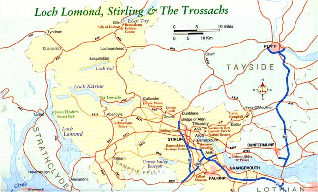
East of Stirling The Rumbling Bridge is signposted on the A823 south of the Yetts o' Muckhart or only a few yards north off the alternate A91. The road passes unhindered over this nineteenth century bridge contradicting the might work of nature below. There is an official Gorge Car Park next to the Rumbling Bridge Nursing Home, otherwise parking on or near the road is rather dangerous.
From the Ice Age and subsequent 10,000 years, fast flowing water has carved a deep, dark gorge in the basalt rock creating an impressive cleft with fern-fringed cascades and deep, dark pools. There are paths and wooden stairs leading to well-constructed viewpoints. A deep pot called the Devil's Mill is where the crashing of the water onto boulders makes an eerie reverberation, much like the sound of an old, working textile mill. To the chagrin of the staunch church-goers of the area, it refused to stop, even on a Sunday - hence its name. The area between the Yetts o' Muckhart and the east side of Stirling is the Clackmannan District or the 'Wee County'. This quiet backwater was once alive with the sounds of industry when the 'Hillfoots' were a thriving manufacturing base for the textile trade of the eighteenth and nineteenth centuries. The lush slopes of the Ochils supplied grazing for sheep, in turn supplying the fabric, while rivers pouring off the hills, became a source of power for the mills that sprang up in the area. By the mid-1800s they had created a busy woollen and tartan manufacturing trade rivalling that of the Scottish Borders. Dollar Because of its reputation as a seat of learning, the town fathers of Dollar discouraged the development of the mill industries, which allowed the town to take on a more genteel air, still palpable today. It is best known for its nineteenth century academy, made possible by John McNabb, a local lad who made a fortune in shipping in London and returned to share his wealth with his home community. Dollar Golf Club is set at the back of town and appears to have no golf course attached to it unless you look above the clubhouse to see the 18th green and 1st tee which gives an indication how hilly this course can be. The road to the right of the river leads to Dollar Glen and Castle Campbell. The glen is a wild, tangled ravine that the waters of the River Devon have deepened through thousands of years. There are three options on how to approach the glen and castle. One is to leave your car in the village and walk up East Bankside and on through the glen, taking around three hours round trip including a stop at the castle for refreshments. Alternatively, you can drive to a car park half way up that still offers a good walk through the glen or up the steep road leading to the castle. Either way is most scenic. Finally, you can drive to a small car park higher up and avoiding the glen altogether. If you are averse to walking at all, there are still some steep hills to be negotiated to the castle. The walk through the glen covers some very rough paths so adequate footwear is necessary. It has been made safer and more accessible with the introduction of stout wooden bridges built by the men of the 75th Engineer Regiment. At the head of the glen, surveying all below it, is Castle Campbell. The castle dates back to the fifteenth century though an earlier fortress did exist on this site. The Campbells of Argyll changed its name from Castle Gloom in 1489 when it was passed to them through marriage. The Campbell family was staunch Presbyterian and invited John Knox here to preach on the knoll now known as Knox's Pulpit. From the castle roof there are excellent views over the village of Dollar to the Forth Valley and beyond. Behind the Castle is the King's Seat, a very popular hill-walking area. The road to Stirling
Carrying on west towards Stirling and behind the town of Alva, there is the romantically named Silver Glen where indications of the silver mines that operated here dating from the seventeenth century are still evident. There is also a complex system of water channels and weirs on the lower slopes of the hill that were once used to power the textile mills of Alva. From here it is relatively easy to scale the Ochils' highest peak, Ben Cleuch at 2,363ft (721m), a hike well rewarded with views over much of Central Scotland. Closer to the north banks of the River Forth, Alloa does not present itself much as a tourist stop having a long tradition as an industrial town with coal mining, textiles production and glass-making but there are several key points that may bear further investigation. The Erskines of Mar, the hereditary keepers of the royal castle of Stirling and one of Scotland's most influential families, made their home here and their fourteenth century tower, recently restored, can be visited. Gartmorn Dam Country Park and Nature Reserve is found near Sauchie. The dam and reservoir were originally created as a source of power for the many textile mills in the area. There is a visitor centre where rangers commence guided walks of the park. Alloa is still dependent on water for their brewing industries as it is still one of the largest brewing centres in Scotland. If you wish to explore the southern banks of the Forth,
which, although now fairly dedicated to the petro-chemical industry, has several
gems worth seeing, then take the A907 from Alloa towards the Kincardine Bridge. |

Thursday, December 26th, 2019
Attention visitors: Tartans.com is back. Please note that this is a snapshot of the site as it existed nearly 20 years ago and you may encounter broken links; we are still combing through the site and correcting those as we find them. Please also note that some sections are currently not functional, primarily the discussion forums/clan chat boards.
|
** HOME - First Time Visitors - Glossary - - Contact Us ** Awards | Bibliography | Clan Calendar | Clan Chat | Clan Finder | History | Famous Scots | Genealogy | Great Hall of the Clans | Links | News and Features | Scots on the Net | Search | Site Map The Gathering of the Clans
Copyright 1995- Tartans.com - All Rights Reserved. |