|
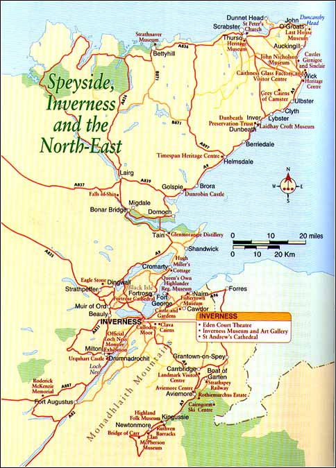
Northern Extremeties John O' Groats For those that have trekked, cycled or pushed a pram all the way from Land's End in Cornwall (Britain's supposed most south-westerly point) to here, John O' Groats, accepted as the most north-eastern point, on a day whipping with wind-driven rain or sleet, they must seriously wonder why they bothered. John O' Groats is really nothing more than a tacky tourist attraction with little to recommend apart from saying that you have been here.
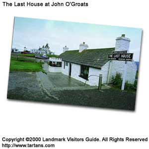
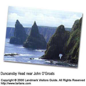
The harbour and the Last House Museum are worth seeing, the latter a tiny old cottage that contains a vivid pictorial display of the naval activities around this area during both World Wars. There is a hotel along with several tourist gift shops selling sea-shells and coconuts, items that have little to do with this part of the world. Of course, you can have your picture taken at the famous John O' Groats signpost. For a more natural encounter, take the minor road to Duncansby Head, some 2 miles (3km) east of 'Groats'. Its impressive rock stacks can be seen after a short walk from the lighthouse parking area or by the boat, which leaves from John O' Groats harbour.
The cliff faces are like high-rise apartments for the myriad of sea-birds nesting on them in the spring and early summer. Their constant squeals echoing off the rocky canyon are quite overwhelming. Guillemots and shags are most common with some puffins burrowing into the grassy edges. There is a good walk out over the headland with the path skirting the cliff edge, which is fenced and fairly safe. Dunnet Head on the other side of John O' Groats, taking the A836, then the B855, is Scotland's true northernmost point. From the lighthouse, on a windy day, you need only sit in your car to watch the incredible aerial displays performed by sea birds catching the up-draughts from the cliffs. A climb up the grassy rise behind the lighthouse affords some wonderful views along the coast with its precipitous rocks. Orkney is clearly seen to the north. Thurso The town of Thurso is found 20 miles (32krn) west of John O' Groats following the A836. It is a well ordered and airy little place with a wide central square, the main shopping areas and hotels leading off it. This was a chief trading port between Scotland and Scandinavia in the Middle Ages exporting beef and fish. Thurso Heritage Museum in the High Street contains the Ulbster Stone, a Pictish relic of some note as well as exhibits gathered by the naturalist Robert Dick. There is also a reconstruction of a croft house kitchen. Near the harbour is Thurso's other tourist attraction, St Peter's Church, a twelfth or thirteenth century construction that was restored in seventeenth century. Thurso's more contemporary claim to fame is the excellent surf it offers off its local beaches. In September and October, international surfing championships bring enthusiasts from around the world. Windsurfing is also popular through the summer months. The Pentland Arms Hotel is said to be the best food in town, although you should try the Bower Inn midway between Thurso and Wick in Castletown or the Upper Deck in Scrabster. Most visitors pass through Thurso to catch the ferry from Scrabster, a short distance north of town, to Stromness in Orkney. There are special days out through the summer where you catch the St Ola and, two hours later, connect with a bus in Stromness for a tour of Orkney's mainland before returning to Scrabster in the evening. Check with the tourist office for more details.
A few miles on is the humpy, single-track route, the
A897, leading south to Helmsdale through an area known as the Flow Country. This
is a flat, peat bog morass with large numbers of limestone lochs that offer excellent
trout fishing. It is also the home to thousands of waders and divers. It may not
be much to look at from the road but, if you know what you are looking for such as
bird life and flora, the Flow Country does have a lot to offer. The A836 carries
on towards Bettyhill and the north-west corner of mainland Scotland. |
Thursday, December 26th, 2019
Attention visitors: Tartans.com is back. Please note that this is a snapshot of the site as it existed nearly 20 years ago and you may encounter broken links; we are still combing through the site and correcting those as we find them. Please also note that some sections are currently not functional, primarily the discussion forums/clan chat boards.
|
** HOME - First Time Visitors - Glossary - - Contact Us ** Awards | Bibliography | Clan Calendar | Clan Chat | Clan Finder | History | Famous Scots | Genealogy | Great Hall of the Clans | Links | News and Features | Scots on the Net | Search | Site Map The Gathering of the Clans
Copyright 1995- Tartans.com - All Rights Reserved. |