|
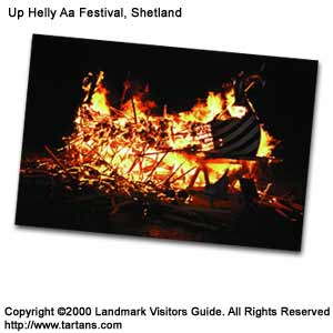
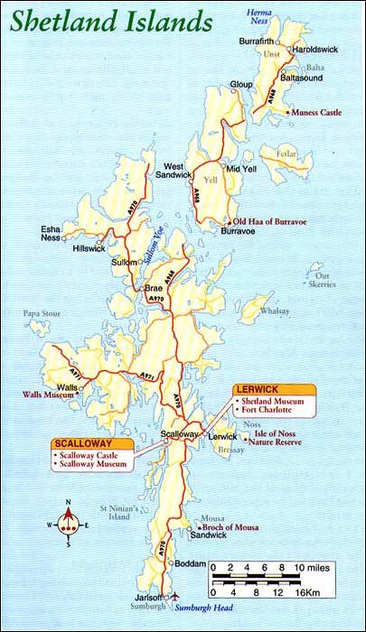
Shetland Compared to the wide, pastoral islands of Orkney, Shetland is a long, stringy strip of land that has given way to the sea at the edges to create its craggy outer islands and skerries. Thrust between the North Sea and the Atlantic Ocean, it offers more rugged and dramatic landscapes than its smoother southerly neighbour does. The terrain is generally quite stark with few bushes and no trees but there is a radiance, a special quality of light that comes from its northerly position. With the 60 degree line of latitude passing through the South Mainland, Bergen in Norway and Torshavn in the Faroe. Isles are as close to Lerwick as Aberdeen, and it is the nearest piece of Britain to the North Pole. Its potentially fierce climate is greatly moderated by the effects of the Gulf Stream and there is plenty of sunshine throughout the summer months. The 'simmer dim' is the term given to the near-endless light through the summer. If you are camping it can be difficult to sleep for the first night or so. Set at the main sea crossroads between Scotland and Scandinavia, like Orkney, Shetland's heritage was strongly Norse. The Vikings, from the eighth to the twelfth century, ruled them but its path in history differed thereafter. The Stewart Earls who drained Orkney's economy, left Shetland alone, while great fishing nations such as the Dutch sought its harbours to take advantage of the bountiful surrounding waters. There are nearly 100 islands, only 15 of which are inhabited. The comforts of modern living and the revenue of a major oil production now balance the harsh landscape that forged the hard working community. Shetlanders are a warm and fascinating people. While the Orcadians became admirable farmers, Shetlanders are noted seafarers and fishermen. Reaching back to their Norse heritage, the men of Shetland exploited deep-sea fishing grounds in the late eighteenth century, working mainly for landlords at ridiculously low wages in boats directly evolved from Viking long-ships-yaols. Today the fishing industry has declined and is centred in Lerwick and Whalsay. Lerwick and Bressay Shetland's capital, Lerwick, lies on the east coast of Mainland, sheltered from the North Sea by the island of Bressay and the Isle of Ness. Being the most northerly town in the British Isles, it is surprisingly cosmopolitan, an international centre for fishermen, oil workers and holidaymakers from around the globe. The main thoroughfare, the flagstone-paved Commercial Street, fairly throngs with foreigners, some from the Russian, Norwegian or Polish factory ships, 'Klondykers', anchored in Bressay Sound with their crews eager to buy up British goods. This has created a thriving market for local shopkeepers and they offer a surprising range of quality items. The P&O ships, the St Claire and the St Sunniva, land at Lerwick from Aberdeen. Sitting above Commercial Street and reached by tiny lanes is Fort Charlotte, built by Cromwell during the Dutch wars when the English were trying to control fishing rights. It is the only Cromwellian fort still in reasonable order. The Dutch burned the fort in 1673. Shetland Museum on Lower Hillhead presents an appealing display of the history of man in Shetland from pre-history to the present. You will hear plenty about the Up-Helly-Aa festivities, no matter what time of year you visit the islands. This pagan New Year festival started in its present form (although its roots are no doubt much older) in the late 1880s as a life-renewing festival and the end of Yule.
An Up-Helly-Aa exhibition is found in a facility off St Sunniva Street. Lerwick's Up-Helly-Aa takes place on the last Tuesday in January although there are Up-Helly-Aa programmes in other commmunities throughout the islands during January and February. Lerwick's is by far the biggest. Opposite the town across the Sound of Bressay is the island of Bressay reached by a regular roll-on roll-off, ferry service from Lerwick. On the far side facing the North Sea is one of the islands most important bird reserves. The Island of Noss Nature Reserve is about 5 miles (8km) east of Lerwick and reachable by inflatable boat. The 600ft (183m) cliffs facing the sea are inhabited by vast colonies of breeding auks, gannets and gulls. The noise can be terrific as it echoes around the fissured rocks.
South Mainland If time is limited, the south part of Mainland contains some of the islands' most interesting parts. From Lerwick, the well-paved A970 stretches down the 24 miles (39km) to Sumburgh Head and the airport. The South Mainland is a long ridge of flat, peat moorland edged by lush meadows. There are no elevations higher than 1,000ft (305m) so views of the ocean are possible, at some points, on both sides of the road. Nowhere in Shetland is further than 3 miles (5km) from the sea. Eleven miles (18km) out of Lerwick on the east side is the village of Sandwick where a thirty passenger boat runs out to the island of Mousa and one of Britain's best preserved brochs, the Broch of Mousa. The broch sits like a giant bee-hive or a small cooling chimney near the sea-edge on this small island and probably, along with a similar structure on Mainland, guarded the Mousa Sound. It is 45ft (14m) high and some 50ft (15m) in diameter with the walls commencing at 12ft (3m) thick and tapering to around 7ft (2m). This was an easily defensible tower built around 2,000 years ago. Only sheep or ponies now inhabit the rest of the island although there is evidence of cottages and crofts, long abandoned. Shetland Croft House Museum is at Boddam, 5 miles (8km) south of Sandwick just off the main road, and it houses furniture made from driftwood in an old Shetlands croft house of the mid-nineteenth century. There are also high-backed Shetland chairs, spinning wheels and domestic baskets woven from heather. There is an old water-mill down the road. Sumburgh International Airport is about 5 miles (8km) south of there on the A970 and it is not unusual to see a white stretch-limo driving up from the airport carrying some oil industry executives. Jarlshof Beyond the airport is Jarlshof, one of the most famous archaeological sites in Britain representing six to eight distinct periods of human habitation covering 3,000 years from Neolithic to Viking times. The popularity of the site through the centuries is attributed to a good anchorage in the adjacent bay, fresh water nearby and green, pastoral land surrounding the site. The remains are fairly sparse but excellent displays around the site as well as the informative guidebook and a small adjacent museum help to illuminate the various multi-layered periods and their dwelling places. The most interesting of these are the wheel-houses of the medieval period. The name Jarlshof was an invention of Sir Walter Scott for his book The Pirate, written after his visit in 1814, but at that time he could not have been sure of the Viking connections. The Sumburgh Hotel is sited next to Jarlshof and provides shelter if the winds are too fierce, as well as excellent bar lunches and very reasonably priced accommodation. About 1 mile south of Jarlshof, off the coast at the tip of Sctness, is the Ness of Burgi, a stone-built defensive structure dating back to the Iron Age and resembling the many brochs of this area. To the west around the Bay of Quendale is the ragged headland of Fitful Head where the Lithuanian oil-tanker Braer, ran aground in a howling gale on 5 January 1993, spilling its cargo of 83,000 tons of crude oil. The disaster was somewhat lessened by the constantly turbulent sea surrounding the coast at the time of year that helped to break up the slicks. The prow of the sunken ship can still be seen. St Ninian's Isle St Ninian's Isle, a glorious little island off the west coast of Mainland, is linked by an hour-glass shaped crescent of shell-sand. On this uninhabited islet are the ruins of a twelfth century church where Aberdeen University students found a hoard of eighth century Pictish silver treasure. This is now on display in the Royal Museum of Scotland in edinburgh-a replica is displayed in Lerwick Museum. Scalloway
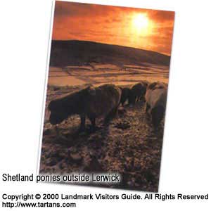
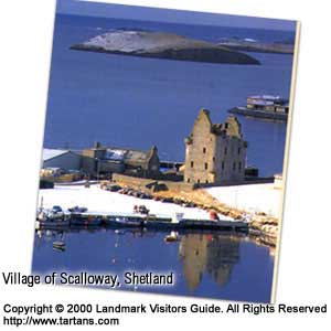
Scalloway Museum in the middle of the village contains fascinating details of the so called 'Shetland Bus', a World War II clandestine shipping operation that maintained communication with the resistance movement in Nazi-occupied Norway. Lunna House, now a guest house in north-east Mainland, was initially the headquarters of the Norwegian Resistance Movement for part of the war, responsible for organising the ferrying of refugees and shipment of secret agents or weapons. Later the H.Q. was transferred to Scalloway. A book called the Shetland Bus by David Howarth tells of the many incidents surrounding these brave affairs. The ruins of Scalloway Castle, a turreted shell that stands on a narrow promontory near the water, dominate Scalloway's narrow streets and ancient cottages. The infamous Earl Patrick Stewart was responsible for its construction in 1600 using forced local labour. His and his son's tyrannical behaviour was known throughout Shetland and Orkney until he was executed for his crimes. Knitwear and glass-blowing workshops are found in the village and these offer some of the best examples of such island crafts. Taking the road south of Scalloway there are bridges crossing to the small islands of Trondra, West Burra and East Burra. West and Central Mainland Returning north, the A971 branches off the mian A970 and, passing Tingwall Airport, leads on to the western spur called West Mainland. This is a bleak but often beautiful prominence that terminates, some 29 miles (47km) away from Lerwick, at its highest point, Sadness Hill at 750ft (229m). Deep-cut voes or fiords and breathtaking coastal scenery that break the monotony of the desolate moorland often divert the road. Walls ids the only village of consequence. There are walks available around the shores or near Sandness which offer views of the island of Papa Stour to the north-west. Papa Stour is reached by passenger ferry from West Burrafirth which operates five days a week during the summer but round trips are only available on Friday and Saturday. The A970 is the main route north on Mainland and from the Walls road this can be reached by taking the Aith road to Voe, the B9071 which joins the main route some miles north. It is a sometimes tortuous winding, single-track route. Easier but less scenic is the shorter single-track route, B9075 further east, which takes you to the workshops around Weisdale and Whiteness that produce fine silver, gold and enamel jewellery following intricate Norse, Celtic and original designs. Heading north-west from here the terrain grows ever wilder with bleak moorland and dramatic voes dappled with simple, white cottages. For those who appreciate such rugged, lonely landscapes this is the place to come. Shetland sheep are frequent road users so take care and allow them time to amble to the side. The famous Shetland ponies are often seen in nearby fields. Salmon, sheep and pony farming play a major part of the economy in these parts. Despite Shetland's success with oil, the landscape in this northern sector remains unspoiled and with the special northern light shimmering off the sea it can be quite enchanting. If the weather is bad it can also be depressing. North Mainland
The minor B9078 leads on west to Brae Wick where there is a natural arch just off the coast, and the road terminates at Esha Ness where there are dramatic cliffs beside the old lighthouse. Puffins particularly favour this area. The north-east part of Mainland is reached by returning east and taking either of the B roads that continue north. The protected eastern shores of this area have been more populated due to their good harbours and access to fishing grounds. If you have never experienced the Aurora Borealis or Northern Lights you have more chance here than in any other part of Scotland. September and October are the most likely months. Returning south, the village of Brae is surprisingly developed. This is accounted for by the large number of oil refinery workers based there. The oil refinery at Sullom Voe, the largest in Europe, is well hidden in a secluded inlet. Yell and Unst If you are setting out to explore the islands of Yell and Unst, be sure to book your accommodation beforehand as it is quite scarce. A drive-on drive-off passenger ferry operates from Toft on the north-east Mainland to the island of Yell. With its lack of foliage, Yell is a rather startling place with grim, heather moors reaching in every direction to the cliff edges. It is a bit of an acquired taste, but for those that are prepared to explore and ignore some of the less attractive sides of life in these remote places, there are wonderful cliff-side walks and ample wildlife, especially seals and otters around the bays and coves. The village of Mid Yell is a busy fishing port in the mid-eastern side of the island where a deep voe reaches across and almost joins with a lengthy fjord coming from the west. Most of the notable habitations are on this eastern coast. The A968 goes all the way to the top of the island where, at Gloup, there is the Gloup Fishermen's Memorial which marks the tragedy of 1881, when 58 men were lost in a great storm. The village of Aywick just south of mid Yell is a good place to find high-quality Shetland knitwear. Further south on the island's south-west corner is the Old Haa (hall) of Burravoe, once the centre of this region's fishing industry and the Old Haa being its oldest building. This former merchant's house now has a museum upstairs which presents the tale of the wrecking of a German sail-ship, the Bohus, in 1924 as well as displays on local flora and fauna, old photographs and taped recordings. There is a tearoom in the Old Haa. The A968 continues north through Yell and onto Unst, Britain's most northerly inhabited island and a contrast to its bleak neighbour, although there are stretches of joyless moorland that are similar. It is rich in bird-life and hosts a range of alpine-artic flowers that draw naturalists from around the world. The A968 heads north towards Baltasound, but turn right at the B9084 to reach Muness Castle on the island's south-west tip. This is Scotland's most northern stronghold built in the late sixteenth century, and Shetland ponies often graze nearby to make a charming picture. Baltasound is the island's main town with the only pub for many miles. This was a fishing centre and evidence of the once great curing sheds can still be seen. The lochs and voes throughout this island provide excellent fishing sport. There is an RAF base on the island which testifies to its strategic position overlooking this confluence of the North Sea, Norwegian Sea and the Atlantic. For those that appreciate flora there is a famous botanical site just over a mile north-east of Baltasound at the Keen of Hamar where thrive various mountain species such as moss campion, Norwegian sandwort and Shetland mouse-ear. Travelling north from Baltasound on the A968 you arrive at Haroldswick with its carmine-coloured post office and small heritage centre. Taking the B9086 north-west from here leads to a wide voe called Burrafirth. From the end of the road there is a path leading to the cliffs at Herma Ness which stand around 600ft (183m) tall and are usually covered with sea birds. The profusion of several varieties such as puffins, gannets and skuas all vying for a place on the sheer rock-face makes for a tumultuous but thrilling scene. Fetlar Returning to Yell, the island of Fetlar is reached on the ro-ro ferry from Gutcher and is called the 'garden of Shetland' - but then most people have just driven through Yell to get there! For the epicurean it offers little except the sheer joy of unaffected scenery and, of course, wild flowers and birds. There is only one settlement, Houbie, a gathering of cottages with an interesting little Interpretative Centre giving an account of the island's history. Fair Isle
The island is best known for its knitwear which differs from that of Shetland, more colourful with designs relating to Scandinavia. However some suggest the use of vivid colour springs from the forced landing of a Spanish ship and its crew in the sixteenth century who encouraged the islanders to brighten up their rather dull patterns. In human terms Fair Isle is one of the most remote
of British islands yet its position is perfect for migrating birds of many varieties
travelling from the Arctic to Africa and back again. There are also some 750, 000
sea birds making it their yearly nesting home. Meanwhile there are only 70 people
resident on the island. The main concentration of this population is around Stonybreck.
Besides the bird life there is spectacular cliff scenery. |
Thursday, December 26th, 2019
Attention visitors: Tartans.com is back. Please note that this is a snapshot of the site as it existed nearly 20 years ago and you may encounter broken links; we are still combing through the site and correcting those as we find them. Please also note that some sections are currently not functional, primarily the discussion forums/clan chat boards.
|
** HOME - First Time Visitors - Glossary - - Contact Us ** Awards | Bibliography | Clan Calendar | Clan Chat | Clan Finder | History | Famous Scots | Genealogy | Great Hall of the Clans | Links | News and Features | Scots on the Net | Search | Site Map The Gathering of the Clans
Copyright 1995- Tartans.com - All Rights Reserved. |