|
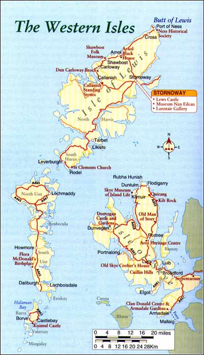
Skye As you look around Portree or Dunvegan there is no doubt that, despite its unpredictable weather, tourism is Skye's main industry. From Kyle of Lochalsh there are two main access points to the island using the ferry from Kyle or via the new road bridge which sweeps from a western tip of the mainland to a point just outside Kyleakin. Further south, taking the famous 'Road to the Isles' from Fort William to Mallaig, you can cross to Skye by ferry to Armadale and land on the southern spur of the island. The railway reached Kyle of Lochalsh in 1897 and, since then, the journey to and 'over the sea to Sky' has been a relatively easy one. The new road bridge, opened in autumn 1995, from Kyle of Lochalsh via the tiny island of Eilean Ban, is the biggest balanced cantilever bridge in the world at 820ft (250m). The Gaelic name for Skye means 'Island of Mist' which most visitors will find apt at some time during a stay. Often several weather conditions will occur in one day so it is best to be prepared for whatever the elements decide.The south
In years gone by travellers came to know Kyleakin, the first village immediately on reaching the island's easternmost peninsula, by simply driving through it on their way to better known places or by queuing for long periods waiting to board the ferry back to the mainland. There is a twelfth century castle visible from the road on a rocky knoll by the water's edge at the entrance to the harbour that can be reached by walking along the beach or clambering over the rocky peninsula. A round-about marks the land-fall for Skye Bridge traffic. There is an excellent little restaurant just beyond called the Crofters Kitchen with a gift shop and licensed bar. Around Broadford Eight miles (13km) on along the A850 is Broadford, the island's second largest community. At the north end of Broadford there is an unusual attraction at the Old Mill, a stone croft-type building signposted as the Serpentarium. Inside is a collection of snakes, lizards and frogs including the uniquely marked Poison Arrow frog from the owner's private collection. He keeps a further 200 snakes at home. If you take a left on the A881 travelling south-west you will come upon the villages of Torrin and Elgol. The reason for this diversion along a single track road is to appreciate one of the best views of the Cuillin Hills. From the beach at Elgol, looking over Loch Scavaig, the great ragged dimensions of these sturdy peaks can be clearly surveyed. There is a small boat that crosses to Loch Coruisk at the foot of the range at least twice a day through the season. As long as the weather is reasonable, the trip is very impressive. Returning to the A850, 7 miles (11km) north-west of Broadford near Luib, you come upon a traditional thatched cottage which is furnished in a turn of the century style that was indigenous to the Highlands and Islands of that time. The Old Skye Crofters House also contains some interesting newspaper clippings, dating from the mid 1800s, when the government attempted to clear the island's small-holders and make way for sheep and hunting sports. The 1886 Crofting Act gave legal tenure and some rights to the local crofters. Armadale Many visitors choose to approach Skye from the more southern mainland port of Mallaig, crossing the Sound of Sleat to Armadale. The A851 then carries north to Broadford. There is a good knitwear and gift shop on the Armadale Pier called Ragamuffin selling hand knits, original cotton clothes, pottery and jewellery. Only half a mile from the pier at Armadale is the Clan Donald Centre, its building adjoining the ruins of Armadale Castle. As well as an opportunity to trace your family roots and learn about the old clan system, the centre gives an excellent introduction to Skye and the Western Islands. Armadale Castle was built in 1815. It is surrounded by 40 acres (16 hectares) of mature gardens from which there are fine views over the Sound of Sleet. Portree Portree is the island's commercial and administrative centre. It was originally known as Kiltaragleann (the church at the foot of the glen) but gained its present title of Portree or Port Righ, meaning the King's Harbour, when James V landed in 1540. Here he tried to unite the bickering clans of the MacLeods and the MacDonalds and also to enlist them to his cause. The most interesting part of Portree is its harbour. People tend to hang out there enjoying the boats or taking a walk up to the Lump, a headland overlooking the bay where they can admire the little cliff-side gardens or take advantage of the best photo-spot of the harbour. This was the site of the local gallows where condemned prisoners were ushered from the jail house, now the tourist office, to meet their fate. The Royal Hotel above the harbour is said to contain the room where Bonnie Prince Charlie bid his farewell to Flora MacDonald following his defeat at the Battle of Culloden in 1746. On the Sligachan Road you find Skye's Heritage Centre. This is one of the newest and best of such exhibitions of Highland and island life with a dramatic and convincing narrative delivered on multi-lingual headsets and based around Skye's history. There is also a very good restaurant and gift shop. On the north side of town is the Skye Woollen Mill and Coffee shop. The Trotternish Peninsula The Trotternish Peninsula stretches above Portree for about 25 miles (40km) to Rubha Hunish and is one of the island's largest and most remote sections. The Old Man of Storr stands like a giant's bowling pin, perched on the side of the hill. It stands 160ft (49m) tall and is part of a landslip that has created several unusual stacks in this area. It is possible to hike to the base of the Old Man of Storr but scaling the stack itself is left only to those with plenty of experience. Towards the shoreline below the Old Man of Storr, an incredible haul of silver broaches, bracelets and other jewellery as well as tenth century coins was uncovered in 1891. This may have been a Norse treasure-trove, and can now be seen as part of the Royal Antiquities Museum of Scotland in Edinburgh. The A855 and A856 form a long 49 mile (79km) loop from Portree and back again via Uig and the western side of the Trotternish peninsula. There are expansive views all along this road to the Applecross peninsula, backed by the ranges of Torridon with the islands of Rona and Raasay in the foreground. At Flodigarry beyond the village of Staffin is the home of Flora MacDonald during her married life from 1751 to 1759. There is a minor road from Quiraing Lodge near Staffa leading to the Quiraing, an eerie set of pinnacles and table top formations that are best experienced on foot. At Duntulm on the western side of the peninsula stands the wreck of Duntulm Castle, once a MacDonald stronghold from where they attempted to control the Hebridean clans during the sixteenth century. A few miles south is the community of Kilmuir and just before it is a cemetery where Flora MacDonald lies buried. The Skye Museum of Island Life is nearby, a group of thatched cottages with farming implements and memorabilia. The spot where Bonnie Prince Charlie was hidden is near Monkstadt House just above the ferry port of Uig. The west From Borve it is possible to drive back into Portree or turn west towards Skeabost and Dunvegan. The Skeabost Hotel on the River Snizort has a challenging little 9 hole golf course. It also offers fishing and is a good place to stop for lunch.
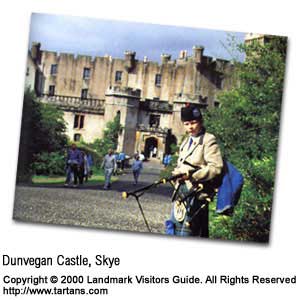
Access into the castle in those days could only be gained from the seaward side. From here the warships of the MacLeod's sailed to control the Western Isles, similar to their Viking predecessors. The castle remains the seat of Macleod of Macleod and has been continuously inhabited for some 750 years. There is a small jetty near the castle's southern flank where boat cruises set off to see seals on the little islands of Loch Dunvegan. It is possible to walk out on the rocks and get a better overall impression of Dunvegan's secure position and there are also several acres of castle gardens to explore. From Dunvegan a minor road leads across the Durinish
Peninsula to the western shores of the island on the Little Minch with views over
to North and South Uist on the Western Isles. The A863 carries on towards Sligachan
and Sconser where you can turn north to Portree or south to the ferry or bridge at
Kyleakin. |
Thursday, December 26th, 2019
Attention visitors: Tartans.com is back. Please note that this is a snapshot of the site as it existed nearly 20 years ago and you may encounter broken links; we are still combing through the site and correcting those as we find them. Please also note that some sections are currently not functional, primarily the discussion forums/clan chat boards.
|
** HOME - First Time Visitors - Glossary - - Contact Us ** Awards | Bibliography | Clan Calendar | Clan Chat | Clan Finder | History | Famous Scots | Genealogy | Great Hall of the Clans | Links | News and Features | Scots on the Net | Search | Site Map The Gathering of the Clans
Copyright 1995- Tartans.com - All Rights Reserved. |